|
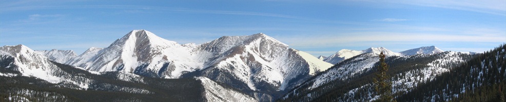
Wilderness Areas in Central Colorado
Over a million acres of wilderness areas for your recreational enjoyment
Buffalo Peaks Wilderness
The Buffalo Peaks Wilderness Area is located in the Pike and San Isabel National Forests. Elevations within the wilderness range from 9,200 feet to over 13,300 feet. The area is characterized by large meadows and forests of Pinyon-juniper, ponderosa pine, and lodgepole pine. Several beautiful stands of bristlecone pine can be found in the southern portion of the wilderness. Wildlife in the area include a large herd of bighorn sheep, elk and mule deer. The towns of Fairplay and Leadville offer access to the Buffalo Peaks Wilderness.
|
Collegiate Peaks Wilderness
A major portion of the Collegiate Peaks Wilderness Area lies within the San Isabel National Forest. The wilderness has 8 peaks over 14,000 feet in elevation. They are Huron Peak (14,005), Missouri Peak (14,067), Mt. Columbia (14,073), Mt. Oxford (14,153), Mt. Yale (14,196), Mt. Belford (14,197), La Plata (14,340), and Mt. Harvard (14,420). The wilderness runs along a 40 mile stretch of the Continental Divide and offers beautiful alpine scenery characterized by numerous cirques and lakes, deep valleys and lofty peaks. The towns of Buena Vista, Leadville, and Salida provide easy access to the Collegiate Peaks Wilderness Area.
|
Greenhorn Mountains Wilderness
The Greenhorn Mountain wilderness is located in the San Isabel National Forest. This is one of Colorado's newest wildernesses, it was designated as part of the 1993 Colorado Wilderness Act. Elevations within the wilderness range from 7,600 feet to over 12,300 feet. The area is unusual since it is composed of both plains and mountains. The entire southern half of the area is trailless. The wilderness is used lightly and offers excellent opportunities for solitude. The towns of Alamosa and Canon City provide access to the Greenhorn Mountains Wilderness.
|
Holy Cross Wilderness
A large portion of the Holy Cross Wilderness lies in the San Isabel National Forest. Elevations within the wilderness range from 8,000 to over 13,000 feet. The wilderness is characterized by numerous pools, streams and alpine lakes in beautiful wide valleys. The town of Leadville provides access to the Holy Cross Wilderness.
|
La Garita Wilderness
Major portions of the La Garita Wilderness is located in the Rio Grande National Forest. "La Garita" means "The Overlook". Elevations within the wilderness range from 9,000 to over 14,000 feet. The Continental Divide National Scenic Trail run through the area along its southern boundary. Wildlife in the La Garita Wilderness includes elk, mule deer, black beer, bobcat, mountain lion, coyote, snowshoe hares, Golden Eagle and other small species. Streams are inhabited by cutthroat, rainbow, brook and brown trout. The town of Alamosa is one of the gateways to the La Garita Wilderness.
|
Lost Creek Wilderness
The Lost Creek Wilderness is in the Pike National Forest. This wilderness area is characterized by clear streams, open parks and granite canyons, walls and domes. The area includes most of 3 mountain ranges, the Platte River, Kenosha, and Tarryall. Elevations within the wilderness range from 8,000 feet to over 12,400 feet. The area got its name because of the number of times that Lost Creek is hidden by boulder piles. The area is home to a large herd of bighorn sheep in addition to mule deer, elk, bobcat and black bear. Vegetation in the area ranges from Lodgepole pine, aspen, spruce fir and bristlecone pine to alpine tundra. The town of Fairplay offers easy access to the Lost Creek Wilderness Area.
|
Mount Evans Wilderness
The southern portion of the Mount Evans Wilderness lies in the Pike National Forest. Accessing the wilderness from the north, the Mount Evans Scenic Byway (SR 5) forms a non-wilderness corridor into the center of the wilderness area. Elevations in the wilderness range from 8,400 to over 14,000 feet. The area is dominated by 14,264 foot Mount Evans and 14,060 foot Mount Bierstadt. About half of the wilderness area is above timber line. The alpine area is characterized by broad expanses of treeless alpine tundra, edged at its lower elevations by krummholz habitat formed of wind-etched and deformed spruce and fir along with stands of bristlecone pine. Broad, thick stands of spruce-fir and lodgepole pine stretch out into the lower valleys. The shape of the area is influenced heavily by alpine glaciation. Surrounding the peaks are deep, steeply faced glacial cirques often holding alpine lakes. Broad U-shaped glacial valleys drop away from the peaks into hummocky, moraine covered valley bottoms, followed by narrow V-shaped canyons. Principal wildlife species include bighorn sheep, mountain goat, elk, marmot, ptarmigan, and grouse. The town of Fairplay is a gateway to the Mount Evans Wilderness.
|
Mount Massive Wilderness
The Mount Massive Wilderness Area is in the Leadville Ranger District of the San Isabel National Forest. The habitat consists of lodgepole pine, spruce and fir forest with small mountain streams, willow and grass riparian habitat. The terrain is rugged, pristine mountain forest ranging in elevation from 10,000 to above timberline tundra peaks over 14,000 feet. Unique wildlife include the green-back cutthroat trout in the Rock Creek drainage, along with typical forest species such as elk, deer, squirrels, grouse, ptarmigan, marmots, pika, skunks, coyotes, bobcats, bear and etc. The town of Leadville is the main gateway to the Mount Massive Wilderness Area.
|
Sangre de Cristo Wilderness
The Sangre De Cristo Wilderness lies within portions of the Rio Grande and San Isabel National Forests. This is one of Colorado's newest wildernesses, it was designated as part of the 1993 Colorado Wilderness Act. This long, narrow wilderness starts at Blanco Peak and extends north for approximately 70 miles. Elevations in the wilderness range from 8,000 feet to 14,294 feet at the top of Crestone Peak. Several other fourteeners are included in the area. The wilderness is characterized by deep valleys, sparkling alpine lakes and beautiful cirques. A total of 180 miles of hiking trails can be found in this beautiful wilderness. The towns of Alamosa, Salida, and Westcliffe offer access to the Sangre de Cristo Wilderness Area.
|
South San Juan Wilderness
A large portion of the South San Juan Wilderness that consists of spectacular mountainous terrain is in the Rio Grande National Forest. The wilderness straddles the Continental Divide south of the famed Wolf Creek Pass, offering high tundra, sweeping vistas, and solitude to the visitor. Elevations within the wilderness range from 8,000 feet to over 13,000. Engelmann spruce and aspen forests cover nearly half of the area, with the rest made up of open grasslands, alpine tundra, and rocky or barren areas. Wildlife that may be observed by visitors include elk, mule deer, bighorn sheep, turkey, and black bear. The town of Alamosa is one of the gateways to the South San Jaun Wilderness.
|
Weminuche Wilderness
The Weminuche Wilderness in the Rio Grande National Forest may be Colorado's wildest land. At the heart of the San Juan Range, the wilderness is cut by 80 miles of the Continental Divide Trail. Scores of peaks rise over 13,000 feet, with three towers in the Needles surpassing 14,000. In a land averaging over 10,000 feet in elevation, alpine meadows and high spruce stands are interspersed with large areas of sharp, granite extrusions and rock slides. The high country originates two drainages that become massive river systems before reaching the sea. To the southwest flow Vallecito Creek, Los Pinos River, Piedra River and the San Juan headwaters, forming the vast San Juan drainage that eventually flows into the Colorado River. To the east, streams like Ute and Weminuche Creeks feed the headwaters of the Rio Grande River. The towns of Alamosa and Creede offer easy access to the Weminuch Wilderness Area. |
South Park Chamber of Commerce: The South Park Chamber of Commerce serves the town of Fairplay and surrounding area. They are an excellent source for information regarding the community and will provide assistance in planning your visit to the area.
The Heart of the Rockies Chamber
of Commerce serves the town of Salida and surrounding area. They are an
excellent source for information regarding the community and will provide
assistance in planning your visit to the area. You can reach them tollfree at 877-772-5432, M - F 9AM to 5PM, MST.
The Lake County Visitors Website serves the towns of Leadville, Twin Lakes, and surrounding area. They are an excellent source for information regarding the community and will provide assistance in planning your visit to the area.

|
|
|