Car Touring in Central Colorado
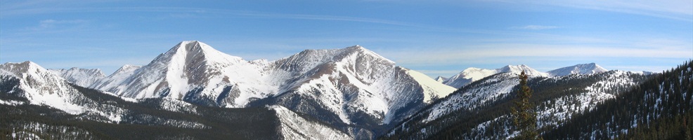
Central Colorado has fantastic scenery
| Car touring is a great way to see the Central Rockies. You will discover old mining camps, frontier towns, scenic mountain lakes, crystal-clear streams, flower-filled meadows, majestic mountains, and much, much more. Almost any road traveled in Central Colorado will have fantastic scenery for you to enjoy. A number of routes take you off the beaten path into regions missed when driving the main highways. Included are day trips that are within one days drive or less from most Central Colorado towns. Driving times when given are approximate and exclude sightseeing. While car touring be sure to stop in the towns along the way. Each town has its own unique history, interesting sites, and things to do. Check the town listing for attractions in each community. |
 |
Scenic & Historic Car Tours
Bachelor Historic Loop
This 17-mile route begins in Creede, Colorado. It takes visitors through Creede's historic silver mining district and past two ghost town sites. The tour begins at the kiosk at the fork of East and West Willow Creek in the canyon north of Creede and ends at the kiosk on State Hwy 149 in Creede. Guide books can be purchased at the Chamber of Commerce or at the kiosk at the south end of Creede. The guide book is a comprehensive narrative of Creede; the last great silver mining boom town in Colorado.
|
Boreas Pass
This scenic tour covers about 30 miles and begins in Fairplay, Colorado. The road to the top of 11,481 foot Boreas Pass follows the route once taken by the narrow gauge Denver, South Park and Pacific Railroad which ran until the early 1930's. At the top of Boreas Pass, you will find the ruins of the town of Boreas Station.
|
Chalk Creek Canyon
This popular drive begins in Buena Vista, Colorado and covers 55 miles round trip, and should take about 2-1/4 hours diving time. Chalk Creek Canyon has a lively, colorful mining and railroad history. Included are views of the Chalk Cliffs--an unusual geologic formation, Agnes Veil Falls, trout filled Chalk Lake, 14ers--Mt. Antero (14,269 ft.) and Mt. Princeton (14,197 ft.), Cascades Canyon, the old mining town of Alpine, an old narrow gauge railroad right-of-way, historic St. Elmo--once a mining and railroad center, ghost towns--Romley and Hancock, and the famous Alpine Tunnel.
|
Clear Creek Canyon/Vicksburg/Winfield
This drive begins in Buena Vista, Colorado and covers 65 miles round trip, and should take about 2 hours driving time. You will visit two well-known ghost towns Vicksburg and Winfield, and get impressive views of four Colorado 14ers--Oxford (14,153 ft.), Belford (14,197 ft.), Missouri (14,067 ft.), and Huron (14,003 ft.). A number of choice picnic spots are along this scenic route.
|
Cottonwood Pass
This drive over the Continental Divide begins in Buena Vista, Colorado. It covers 36 miles round- trip, and should take about 2 hours driving time. Cottonwood Pass at 12,126 feet is one of the highest passes in the U.S. over the Continental Divide. Cottonwood Pass is scenic and takes you through an area with many points of interest, including a possible side trip to Cottonwood Lake. Be sure to take your camera and binoculars. This trip provides an opportunity to see some of Colorado's wildlife. Bighorn sheep, deer, and mountain goats are sometimes seen along this road.
|
Frontier Pathway Scenic Byway
This drive near the Colorado towns of Canon City and Westcliffe. It covers about 103 miles, the driving time is about 3.5 hours. Hardscrabble Canyon, the pristine Wet Mountain Valley, sharp mesas and hogbacks flanking the Arkansas River highlight this unspoiled historic and scenic route. Homesteads and vintage ranches, some dating back to the 1840's, romantic stage-stop ruins, and abandoned trading posts form living "memories of the past." View the entire 100-mile length of the Sangre de Cristo Range which has seven peaks over 14,000 feet, and 39 peaks over 13,000 feet.
|
Georgia Pass
This drive covers 21 miles and begins in Fairplay, Colorado. Georgia Pass (11,585 ft.) is located on the Continental Divide and provides travelers with spectacular views of South Park. This road was one of the first transportation routes to the Breckenridge area during the region's gold discovery era.
|
Gold Belt Tour Scenic Byway
In the early 1890s the mining towns of Colorado enjoyed the greatest gold boom the state has ever known. This historic tour covers a 131-mile scenic loop, and should take about 5 hours driving time. The circuit tours historic Cripple Creek, Florence, McCourt, Adelaide, Wilbur, Victor, and other former gold camps. The roads are narrow and rugged in places - one stretch of the Shelf Road clings to a canyon wall 200 feet above the stream bed - but the payoff comes in the outstanding scenery: majestic Pikes Peak, the unspoiled Beaver Creek Wilderness Study Area, spectacular Royal Gorge, and miles of high-country beauty. Two significant fossil areas - Florissant Fossil Beds National Monument and the Garden Park Dinosaur Fossil Area - lie along the route.
|
Golden Loop Historic Parkway Driving Tour and Trails
A self-guided 17 mile driving tour of the Cripple Creek and Victor mining district. Tour guide booklets are 50 cents and are available at Victor businesses and the Cripple Creek Welcome Center. A self-guided hiking, biking, horseback trail starts in Vindicator Valley near Victor and winds 2-plus miles through historic mining artifacts.
|
Silver Thread Scenic Byway
The colorful old mining camps of the Silver Thread offer history, scenic beauty, and a heavy dose of authenticity. The heights around Creede and Lake City remain strewn with abandoned mining structures, most of them accessible via rugged backcountry roads. Between the two towns, State Hwy 149 shadows the upper reaches of the Rio Grande, serving up a bounty of natural wonders - sparkling North Clear Creek Falls, the Slumgullion earth slide, and the shark-like fin of Uncompahgre Peak. These mountains can be unforgiving: In 1848 explorer John C. Fremont lost a third of his men - and a quarter of a century later the infamous Alfred Packer cannibalized his companions - in two ill-fated winter expeditions.
|
Los Caminos Antiguos Scenic Byway
This historic byway covers 129 miles and takes about 3 hours one way. Explore the rich culture and traditions of some of Colorado's oldest communities and the panoramic views of the San Juan and Sangre de Cristo Mountain ranges, the high, fertile San Luis Valley, The Great Sand Dunes National Monument, state and federal parks and wildlife areas. Los Caminos Antiguos take you to Colorado's oldest surviving community (San Luis, 1851), the oldest church (Our Lady of Guadalupe, in Conejos), and one of its first military posts (Fort Garland).
|
Top Of The Rockies Scenic Byway
This 75-mile tour takes about 2 hours 15 minutes driving time. With altitudes seldom dipping below 9,000 feet, this byway is worthy of its name. It crosses the 10,424-foot Tennessee Pass enroute to the historic mining town of Leadville, the highest incorporated community in the U.S. Ghost towns attest to the state's rich mining heritage. The route crosses the Continental Divide twice and traces the Arkansas River nearly to its source in the vicinity of Fremont Pass. The byway provides access to one of the largest concentrations of Congressionally designated Rare II Wilderness in the nation. |
|
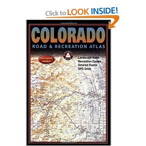
Colorado Road & Recreation Atlas
Colorado’s mountains are the source of everything that makes Colorado unique. No other publication can display this entrancing scenery and its recreation potential with more precision than Benchmark’s new Colorado Road & Recreation Atlas. The Landscape Maps™ reveal landforms with amazing realism and detail clearly showing how the state’s vast network of roads and local recreation landmarks fit into the countryside. A complete 30-page Recreation Guide lists a myriad of outdoor activities, arranged by category, and is the ideal planning tool for adventures from a simple day-hike to an extended backcountry expedition. |
|

|
|